Sugarloaf Ridge State Park
|

Sugarloaf Ridge, looking South from near the top of Bald
Mountain. On a clear day, the views from the top of Bald Mountain
are magnificent and include the Sierras to the East, San Francisco Bay and
Mount Diablo to the South, Mount Tamalpais to the South-West, the Coastal
Range and the Pacific to the West and Mount Saint Helena to the
North. |
|
"A rough smack of resin was in the air, and a crystal mountain
purity. It came pouring over these green slopes by the oceanful. The woods
sang aloud, and gave largely of their healthful breath. Gladness seemed to
inhabit these upper zones, and we had left indifference behind us in the
valley ... There are days in a life when thus to climb out of the lowlands
seems like scaling heaven."
|
Ferguson Observatory.
In 1996, Sugarloaf Ridge State Park became the home of the largest
observatory in the western United States which is completely dedicated to public
viewing and education. For public viewing schedule, see the
Parks Walk Schedule.
How to get there: From Highway 12, take Adobe Canyon Road just
North-East of Kenwood to the park.
Area
Map
Can I bring my dog to the park?
Sugarloaf State Historic Park
Sugar wasn't always sold in the neat paper packages that we buy at the
supermarket these days. Before the turn of the century, it came in loaves that
looked something like oversized, upside-down ice cream cones; the grocer just
broke off pieces for his customers. So, many western mountains and hills
including the ridge at the southern edge of this park were named after the
familiar "Sugarloaf."
An excellent view of Sugarloaf Ridge can be
obtained from the intersection of Highway 12 and Adobe Canyon Road.
The
park is located northeast of Kenwood in the Mayacamas Mountains between the
Sonoma and Napa valleys. Elevations within the 2,700 acre park range from 600
feet at the entrance to 2,729 feet at the top of Bald Mountain, which overlooks
the Napa Valley with Mount Saint Helena to the north. On very clear days the
view includes portions of the San Francisco Bay Area and even a glimpse of the
Sierra Nevada.
Twenty-one miles of trail wind through three distinct
ecological systems: chaparral-covered ridges, oak/fir forest land along the open
meadows, and redwood forest in the canyon of Sonoma Creek. Trees include
big-leaf maple, madrone, California laurel, gray pine, Douglas-fir, alder,
California buckeye, coast redwood, and several varieties of live and deciduous
oaks. The chaparral community includes manzanita, chamise, California lilac,
coyote bush, toyon, and winebush. As you hike, watch out for poison oak and,
along the creek, stinging nettles.
Sonoma Creek begins in the park and
runs for three miles through its southern portion. It's too shallow for
swimming, and often dries up by late summer, so fishing (for trout) is best in
late spring/early summer. The creek is not planted. Season dates and stream
closures vary each year; check the current California Fish and Game regulations.
Anglers over 16 must have a fishing license.
Summers at Sugarloaf Ridge are hot and dry. High temperatures are often in
the 90s, but it usually cools down in the evening to the 40s. Ocean fog
sometimes penetrates this far inland. Most of the park's forty inches or so of
rain come between November and April. Light snow falls occasionally. Wintertime
low temperatures drop into the 30s with daytime highs in the 50s and
60's.
People find this area most enjoyable during the spring and fall.
After the winter rains, there is a picturesque 25-foot waterfall along Sonoma
Creek below the campground. Also in the spring, the park comes alive with
wildflowers including California poppies, cream cups, lupine, penstemon,
buttercups, several varieties of pea, shooting stars, trillium, and Indian
warrior. Less common are golden fairy lantern, zigadene, and fritillaria. In the
early summer come clarkia, scarlet larkspur, farewell-to-spring, Mariposa
lilies, monkey flowers, and Indian pinks. Yellow star thistles and tarweed are
common in late summer.
Along the creek near the entrance to the
campground, there is a visitor center with general information as well as a
guide to the natural and cultural history of the park.
On certain dates, there are docent-led walks which offer
visitors interpretive talks of the history and ecology of the park. The
Schedule is updated
monthly.
Camping and Picnicking
The park's family campground and picnic area lie in the meadow near Sonoma
Creek at 1,200 feet elevation. Each of the 50 campsites has a table and fire
ring. Flush toilets and drinking water are nearby, though there are no
washbasins or showers. The sites will accommodate trailers and campers up to 24
feet long. The 16 family picnic sites have tables and barbecues, and there is a
large parking area nearby for daytime visitors.
The group camp area,
which will accommodate up to 50 people, has large barbecues, fire rings, water
faucets, pit toilets and several small corrals for horses.
For reservations,
call Reserve America at 1-800-444-7275
The Wappo Indians
The Wappo Indian village of Wilikos was located at the headwaters of Sonoma
Creek before the first Spanish settlers came to California. Almost every trace
of the village has now disappeared, and we can only wonder what life was like in
Wilikos.
The houses people lived in were dome-shaped huts as much as 40
feet long, made of poles and grass thatch. The one hundred or so residents lived
in about forty of these dwellings. A larger structure, a sweat house, in the
center of the village was used by the men for smoking, steam baths, and various
ceremonial purposes.
If you had visited here then, you might have seen
women gathering acorns and other seed crops, or working on baskets or tanning
hides for clothing. The men might be preparing for the next hunt, or out in the
hills looking for game. Then again you might have arrived during a festival or
ceremony and participated in games, dancing, and feasting.
You might have
talked with the chief of war or of ceremonials, or of news. These "chiefs" were
not absolute rulers, but served the community more nearly like consultants each
with an area of special expertise. If you needed medical help, for example,
there were several specialists to choose from-none of whom took payment unless
you were cured. At the time of your visit, some of the villagers would very
likely be away, traveling to the sea to gather fish or other seafood as well as
clam or abalone shells for trade, or walking to the area now known as Anderson
Marsh State Historic Park near Clear Lake to fish or trade with the Pomo Indians
of that area. Obsidian for arrow points and other purposes was obtained from
quarries on the slopes of Mount Saint Helena.
The Wappo resisted Spanish
intrusion more strongly than some other Indian groups. Their name is a
corruption of the Spanish word "guappo", which means "brave" or "daring." But
though they were successful in resisting military takeover, their numbers were
sharply reduced by the disastrous cholera epidemic of 1 833 and the equally
terrible smallpox epidemic of 1838. Most of those who survived were eventually
relocated to the Mendocino Indian reservation.
Ranching
American settlers who came early to California were interested in the fertile
land of the valleys, but by the 1860s and '70s some of them had settled in the
hills near Sugarloaf Ridge. Farming here was limited and marginal. One settler
supplemented his income by making charcoal for sale in San Francisco.
Eventually, Sugarloaf Ridge was owned by "gentlemen farmers" whose ranch
operations were run by hired managers while they tended their businesses in
town.
The State bought the property in 1920 in order to dam the creek and
provide water for Sonoma State Hospital. But property owners along the creek
objected, and until World War l II use of the area was limited to camping,
picnicking, and a Boy Scout camp. In 1942 the area was leased out for grazing,
and in 1964 it became part of the State Park System.
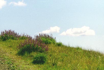
Sugarloaf Ridge State Park is one of the finest places to see
springtime flowers of many varieties. Here we see several clumps of
lupines.
For more information contact:
Sugarloaf Ridge State Park
2605 Adobe
Canyon Road
Kenwood, CA 95452-9004
(707)
833-5712
or
Silverado District
20 East Spain Street
Sonoma,
CA 95476-5729
(707) 938-1519
Volunteer Opportunities at Sugarloaf State Park
Return to
Parks Home
Page